 EAA Chapter 430
KNUW Air Traffic Control Brochures
Open the PDF at page 5 See the whole April 2024 issue
The following handout was issued by LCDR R. M. Connell, Installation Aviation Safety Officer, Naval Air Station Whidbey Island and to be shared broadly for those that fly the airspace. This does not come through official FAA channels and information consolidated here is public, most that can be found on your charts and chart supplement or FOIA. Do note that while on mission in hot zone
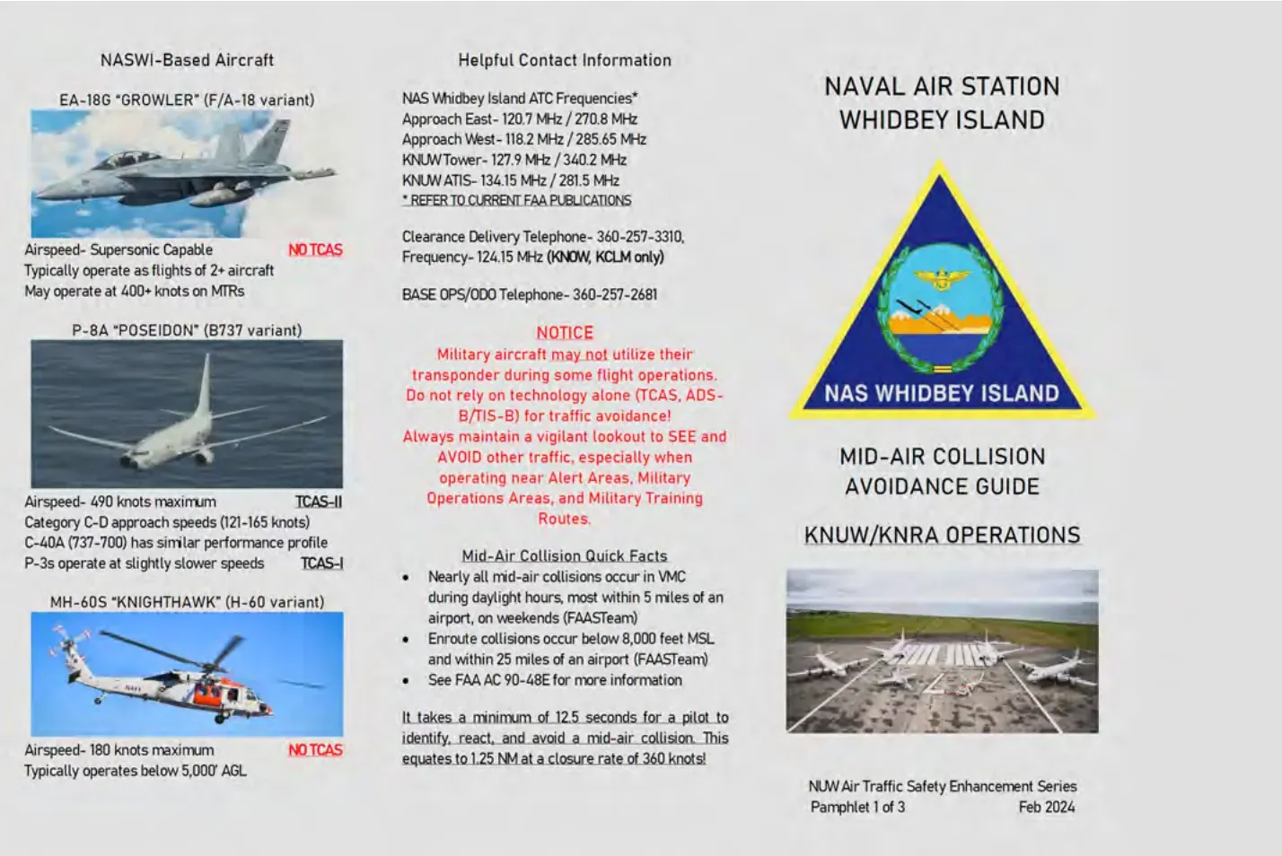
Pamphlet 1 of 3: Mid-Air Collision Avoidance Guide, KNUW/KNRA Operations
NASWI-Based Aircraft
EA-18G “GROWLER” (F/A-18 variant): Airspeed- Supersonic Capable. NO TCAS. Typically operate as flights of 2+ aircraft. May operate at 400+ knots on MTRs.
P-8A “POSEIDON” (B737 variant): Airspeed- 490 knots maximum. TCAS-II. Category C-D approach speeds (121-165 knots). C-40A (737-700) has similar performance profile. P-3s operate at slightly slower speeds. TCAS-I.
MH-60S “KNIGHTHAWK” (H-60 variant): Airspeed- 180 knots maximum. NO TCAS. Typically operates below 5,000’ AGL.
Helpful Contact Information
NAS Whidbey Island ATC Frequencies*: Approach East- 120.7 MHz / 270.8 MHz. Approach West- 118.2 MHz / 285.65 MHz. KNUW Tower- 127.9 MHz / 340.2 MHz. KNUW ATIS- 134.15 MHz / 281.5 MHz. * REFER TO CURRENT FAA PUBLICATIONS
Clearance Delivery Telephone- 360-257-3310, Frequency- 124.15 MHz (KNOW, KCLM only)
BASE OPS/ODO Telephone- 360-257-2681
NOTICE: Military aircraft may not utilize their transponder during some flight operations. Do not rely on technology alone (TCAS, ADS-B/TIS-B) for traffic avoidance! Always maintain a vigilant lookout to SEE and AVOID other traffic, especially when operating near Alert Areas, Military Operations Areas, and Military Training Routes.
Mid-Air Collision Quick Facts
- Nearly all mid-air collisions occur in VMC during daylight hours, most within 5 miles of an airport, on weekends (FAASTeam)
- Enroute collisions occur below 8,000 feet MSL and within 25 miles of an airport (FAASTeam)
- See FAA AC 90-48E for more information
It takes a minimum of 12.5 seconds for a pilot to identify, react, and avoid a mid-air collision. This equates to 1.25 NM at a closure rate of 360 knots!
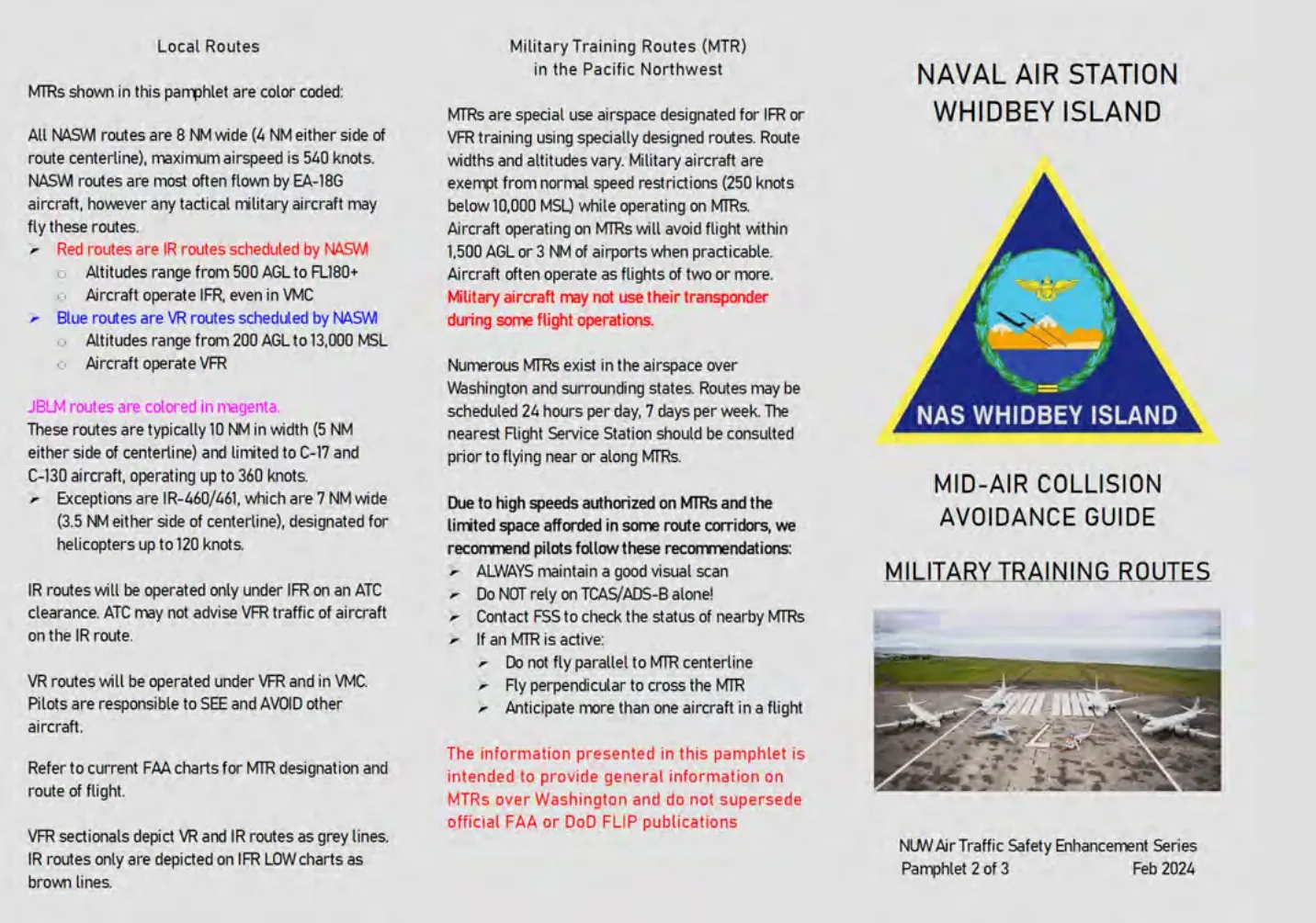
Pamphlet 2 of 3: Military Training Routes
Local Routes
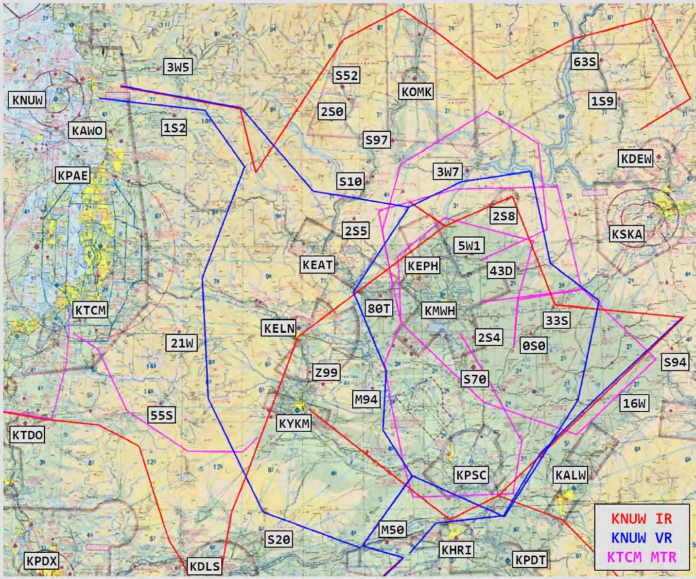
MTRs shown in this pamphlet are color coded:
All NASW routes are 8 NM wide (4 NM either side of route centerline), maximum airspeed is 540 knots. NASW routes are most often flown by EA-18G aircraft, however any tactical military aircraft may fly these routes.
- Red routes are IR routes scheduled by NASW. Altitudes range from 500 AGL to FL180+. Aircraft operate IFR, even in VMC
- Blue routes are VR routes scheduled by NASW. Altitudes range from 200 AGL to 13,000 MSL. Aircraft operate VFR
JBLM routes are colored in magenta. These routes are typically 10 NM in width (5 NM either side of centerline) and limited to C-17 and C-130 aircraft, operating up to 360 knots.
- Exceptions are IR-460/461, which are 7 NM wide (3.5 NM either side of centerline), designated for helicopters up to 120 knots.
IR routes will be operated only under IFR on an ATC clearance. ATC may not advise VFR traffic of aircraft on the IR route.
VR routes will be operated under VFR and in VMC. Pilots are responsible to SEE and AVOID other aircraft.
Refer to current FAA charts for MTR designation and route of flight.
VFR sectionals depict VR and IR routes as grey lines. IR routes only are depicted on IFR LOW charts as brown lines.
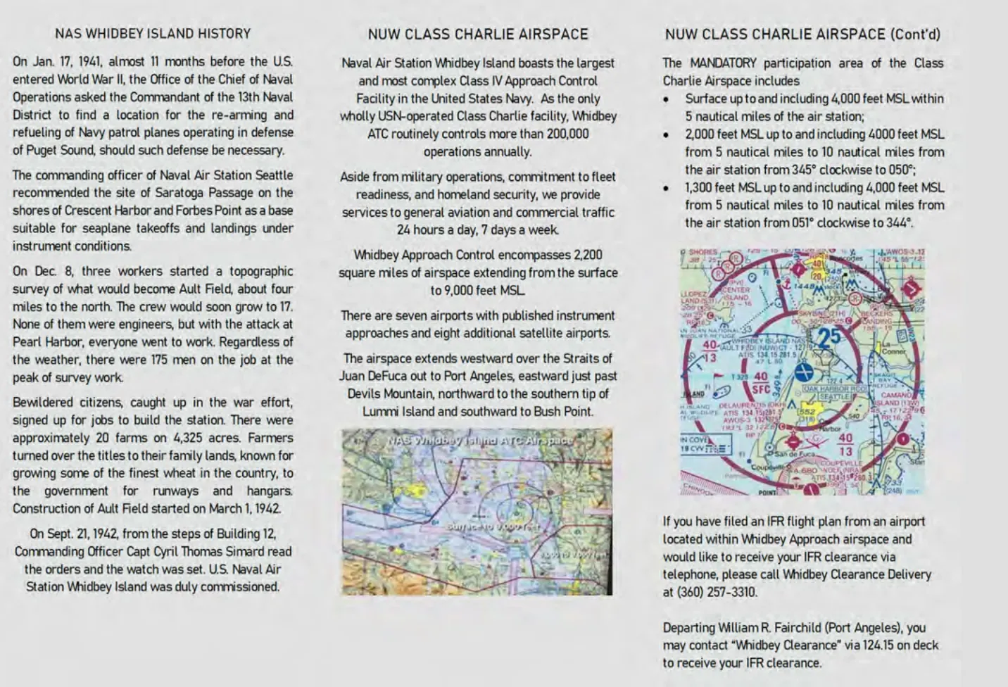
NAS Whidbey Island History
On Jan. 17, 1941, almost 11 months before the U.S. entered World War II, the Office of the Chief of Naval Operations asked the Commandant of the 13th Naval District to find a location for the re-arming and refueling of Navy patrol planes operating in defense of Puget Sound, should such defense be necessary.
The commanding officer of Naval Air Station Seattle recommended the site of Saratoga Passage on the shores of Crescent Harbor and Forbes Point as a base suitable for seaplane takeoffs and landings under instrument conditions.
On Dec. 8, three workers started a topographic survey of what would become Ault Field, about four miles to the north. The crew would soon grow to 17. None of them were engineers, but with the attack at Pearl Harbor, everyone went to work. Regardless of the weather, there were 175 men on the job at the peak of survey work.
Bewildered citizens, caught up in the war effort, signed up for jobs to build the station. There were approximately 20 farms on 4,325 acres. Farmers turned over the titles to their family lands, known for growing some of the finest wheat in the country, to the government for runways and hangars. Construction of Ault Field started on March 1, 1942.
On Sept. 21, 1942, from the steps of Building 12, Commanding Officer Capt Cyril Thomas Simard read the orders and the watch was set. U.S. Naval Air Station Whidbey Island was duly commissioned.
Military Training Routes (MTR) in the Pacific Northwest
MTRs are special use airspace designated for IFR or VFR training using specially designed routes. Route widths and altitudes vary. Military aircraft are exempt from normal speed restrictions (250 knots below 10,000 MSL) while operating on MTRs. Aircraft operating on MTRs will avoid flight within 1,500 AGL or 3 NM of airports when practicable. Aircraft often operate as flights of two or more. Military aircraft may not use their transponder during some flight operations.
Numerous MTRs exist in the airspace over Washington and surrounding states. Routes may be scheduled 24 hours per day, 7 days per week. The nearest Flight Service Station should be consulted prior to flying near or along MTRs.
Due to high speeds authorized on MTRs and the limited space afforded in some route corridors, we recommend pilots follow these recommendations:
- ALWAYS maintain a good visual scan
- Do NOT rely on TCAS/ADS-B alone!
- Contact FSS to check the status of nearby MTRs
- If an MTR is active:
- Do not fly parallel to MTR centerline
- Fly perpendicular to cross the MTR
- Anticipate more than one aircraft in a flight
The information presented in this pamphlet is intended to provide general information on MTRs over Washington and do not supersede official FAA or DoD FLIP publications
NUW Class Charlie Airspace
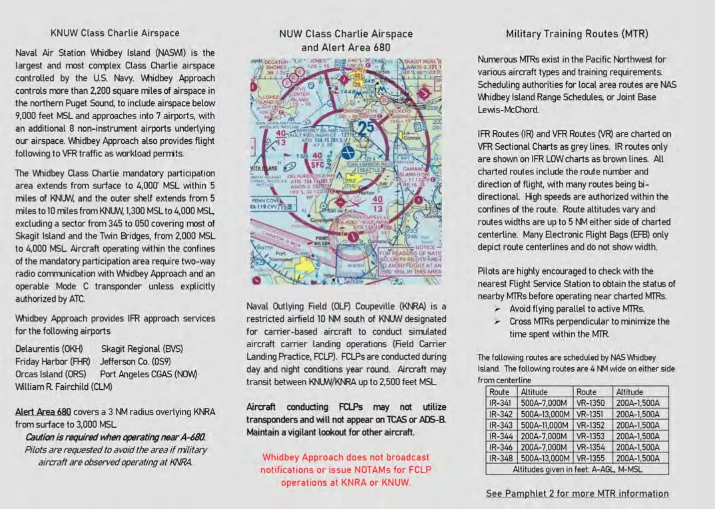
Naval Air Station Whidbey Island boasts the largest and most complex Class IV Approach Control Facility in the United States Navy. As the only wholly USN-operated Class Charlie facility, Whidbey ATC routinely controls more than 200,000 operations annually.
Aside from military operations, commitment to fleet readiness, and homeland security, we provide services to general aviation and commercial traffic 24 hours a day, 7 days a week.
Whidbey Approach Control encompasses 2,200 square miles of airspace extending from the surface to 9,000 feet MSL
There are seven airports with published instrument approaches and eight additional satellite airports.
The airspace extends westward over the Straits of Juan DeFuca out to Port Angeles, eastward just past Devils Mountain, northward to the southern tip of Lummi Island and southward to Bush Point.
NUW Class Charlie Airspace (Cont’d)
The MANDATORY participation area of the Class Charlie Airspace includes
- Surface up to and including 4,000 feet MSL within 5 nautical miles of the air station;
- 2,000 feet MSL up to and including 4000 feet MSL from 5 nautical miles to 10 nautical miles from the air station from 345° clockwise to 050°;
- 1,300 feet MSL up to and including 4,000 feet MSL from 5 nautical miles to 10 nautical miles from the air station from 051° clockwise to 344°.
If you have filed an IFR flight plan from an airport located within Whidbey Approach airspace and would like to receive your IFR clearance via telephone, please call Whidbey Clearance Delivery at (360) 257-3310.
Departing William R. Fairchild (Port Angeles), you may contact “Whidbey Clearance” via 124.15 on deck to receive your IFR clearance.
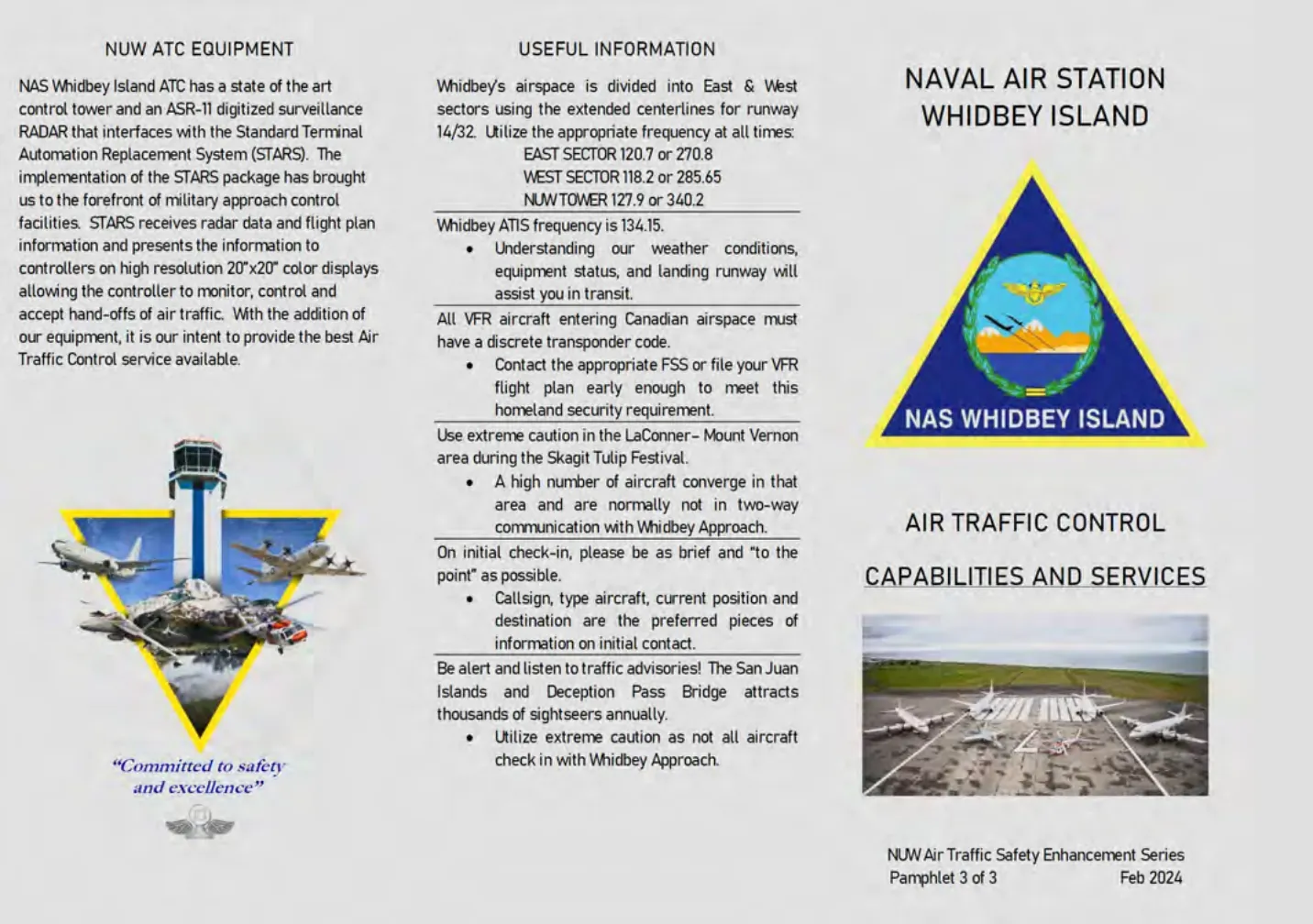
Pamphlet 3 of 3: Air Traffic Control Capabilities and Services
NUW ATC Equipment
NAS Whidbey Island ATC has a state of the art control tower and an ASR-11 digitized surveillance RADAR that interfaces with the Standard Terminal Automation Replacement System (STARS). The implementation of the STARS package has brought us to the forefront of military approach control facilities. STARS receives radar data and flight plan information and presents the information to controllers on high resolution 20”x20” color displays allowing the controller to monitor, control and accept hand-offs of air traffic. With the addition of our equipment, it is our intent to provide the best Air Traffic Control service available.
“Committed to safety and excellence”
Useful Information
Whidbey’s airspace is divided into East & West sectors using the extended centerlines for runway 14/32. Utilize the appropriate frequency at all times:
- EAST SECTOR 120.7 or 270.8
- WEST SECTOR 118.2 or 285.65
- NUW TOWER 127.9 or 340.2
Whidbey ATIS frequency is 134.15.
- Understanding our weather conditions, equipment status, and landing runway will assist you in transit.
All VFR aircraft entering Canadian airspace must have a discrete transponder code.
- Contact the appropriate FSS or file your VFR flight plan early enough to meet this homeland security requirement.
Use extreme caution in the LaConner- Mount Vernon area during the Skagit Tulip Festival.
- A high number of aircraft converge in that area and are normally not in two-way communication with Whidbey Approach.
On initial check-in, please be as brief and “to the point” as possible.
- Callsign, type aircraft, current position and destination are the preferred pieces of information on initial contact.
Be alert and listen to traffic advisories! The San Juan Islands and Deception Pass Bridge attracts thousands of sightseers annually.
- Utilize extreme caution as not all aircraft check in with Whidbey Approach.